Trail Walking Val d'Anast - circuit des landes et des étangs. Campel - Photo

circuit des landes et des étangs. Campel

 slm3005
slm3005

User

© OpenStreetMap contributors
Length
Length
14.9 km
Max alt
Max alt
131 m
Uphill gradient
Uphill gradient
212 m
Km-Effort
Km-Effort  
17.8 km
Min alt
Min alt
79 m
Downhill gradient
Downhill gradient
213 m
Boucle
Boucle
Yes
Creation date :
2014-12-10 00:00:00.0
Updated on :
2014-12-10 00:00:00.0

(1 Reviews)

Walking
Walking
3h34
Difficulty : Very easy

Scan this QR Code to open this trail in the SityTrail application

FREE GPS app for hiking

Logo SityTrail SityTrail

IGN / Geographical institutes

Download SityTrail from the App Store Download SityTrail from Google Play

Logo SityTrail SityTrail World

The world is yours!

Download SityTrail from the App Store Download SityTrail from Google Play Download SityTrail on Huawei AppGallery

About

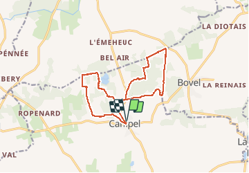
Trail Walking of 14.9 km to be discovered at Brittany, Ille-et-Vilaine, Val d'Anast. This trail is proposed by slm3005.

Description

Attention balisage très moyen par endroit.

Elevation profile

Photos

Points of interest

Point of interest Val d'Anast - Étang  - Photo
slm3005
VAL D'ANAST 
Point of interest Val d'Anast - four à pain.  - Photo
slm3005
VAL D'ANAST 
Point of interest Val d'Anast - étang de Livry - Photo
slm3005
VAL D'ANAST 

Positioning

Country:
France
Region :
Brittany
Department/Province :
Ille-et-Vilaine
Municipality :
Val d'Anast
Location:
Unknown
Start:(UTM)
574074 ; 5309812 (30T) N.

Comments

Please log in to post a review or rate the element


Trails nearby

Trail Walking Val d'Anast - Les étangs de Campel - Photo
Walking
jackpot

Walking

Medium
Val d'Anast, Brittany, Ille-et-Vilaine, France
10 km | 11.7 km-effort
2h 41min
Yes
Trail Walking Val d'Anast - Circuit des étangs et des Landes - Campel - Photo
Walking
tracegps

Walking

Difficult
(3)
Val d'Anast, Brittany, Ille-et-Vilaine, France
13.7 km | 16.3 km-effort
3h 25min
Yes
Trail On foot Maxent - Circuit de L'Emeheuc - Photo
On foot
PRO

On foot

Easy
Maxent, Brittany, Ille-et-Vilaine, France
7.2 km | 8.5 km-effort
1h 55min
Yes
Trail Walking Bovel - Circuit du Bois de Cent Jours - Bovel - Photo
Walking
tracegps

Walking

Easy
Bovel, Brittany, Ille-et-Vilaine, France
5.6 km | 7 km-effort
1h 19min
Yes
Trail Walking Val d'Anast - campel - Photo
Walking
Erick Marteau

Walking

Medium
Val d'Anast, Brittany, Ille-et-Vilaine, France
14.1 km | 16.7 km-effort
3h 7min
Yes
Trail Walking Val d'Anast - campeljuin - Photo
Walking
ballay

Walking

Very easy
Val d'Anast, Brittany, Ille-et-Vilaine, France
12.2 km | 14.4 km-effort
2h 46min
No
Trail sport Val d'Anast - 2023-03-02_11h00m56_SityTrail - 3565569 - Campel_TA_Rando A+ - Photo
sport
ballay

sport

Very easy
Val d'Anast, Brittany, Ille-et-Vilaine, France
13.2 km | 15.8 km-effort
Unknown
No
Trail Walking Val d'Anast - 180 Rando des étangs et des Landes Campel - Photo
Walking
Pierre-yves Leclerc

Walking

Easy
Val d'Anast, Brittany, Ille-et-Vilaine, France
14.1 km | 16.7 km-effort
3h 11min
Yes
Trail Walking Maxent - Maxent TA 10/10/2019 - Photo
Walking
nolsim

Walking

Very easy
(1)
Maxent, Brittany, Ille-et-Vilaine, France
11.8 km | 13.7 km-effort
2h 44min
No


Close
My subscriptions